







- Google Maps can help truck drivers navigate, but it does not offer truck-specific routing.
- The app cannot account for low bridges, weight limits, hazmat restrictions, or truck-prohibited roads.
- Relying solely on Google Maps can lead to costly detours, delays, fines, and safety risks.
- Many truck drivers use Google Maps for traffic updates, location search, and pre-trip planning rather than primary navigation.
- Dedicated truck GPS apps provide safer, compliant routes based on vehicle dimensions and road restrictions.
- For long-haul, oversized, or commercial trucking operations, a truck-specific navigation app is the better choice.
Google Maps can be used for trucks, but it isn’t designed for commercial vehicle navigation. Unlike dedicated truck GPS apps, Google Maps doesn’t account for vehicle height, weight, axle count, hazardous materials, low-clearance bridges, or truck-restricted roads.
As a result, truck drivers who rely solely on Google Maps risk being routed onto unsafe or non-compliant roads, leading to delays, fines, and costly detours.
That doesn’t mean Google Maps is useless for trucking. Many drivers still use it to check traffic conditions, find customer locations, explore routes with Street View, and locate nearby services. The key is understanding where Google Maps helps and where it falls short.
In this guide, we’ll explain whether Google Maps is safe for trucks, the risks of using it as your primary navigation tool, when it may be good enough for commercial drivers, and the best alternative truck GPS apps for safer, more compliant routing.
Table of Content
Does Google Maps Have Truck GPS?
Not in any meaningful sense for commercial drivers. While it handles basic point-to-point navigation, it has no awareness of height limits, weight caps, hazmat rules, or any other commercial vehicle restriction — so the routes it generates are built for cars, not trucks.
More importantly, understanding its pros and cons will help you decide whether it’s suitable for your operations.
Why Truck Drivers Prefer Using Google Maps for Route Planning?
1. User-friendly interface
Google Maps has a simple interface familiar to everyone, including truckers, making it easy for them to use and navigate roads.
2. Cost-effectiveness
Unlike truck GPS apps that require heavy upfront installation and onboarding costs, Google Maps for trucks is free to download and use. This makes it cost-effective, especially for small transportation companies with tight budgets, though its lack of truck-specific features limits its practical value for commercial drivers.
3. Cross-platform compatibility
Google Maps is compatible with a broad range of devices, including smartphones, tablets, and in-vehicle infotainment systems. This easy access across all device types improves flexibility and usability for you and your drivers.
Why Google Maps Is Not Designed for Truck Routing?
While Google Maps provides multiple navigation modes, including driving, public transit, cycling, and walking, it doesn’t support the truck mode.
This makes it not the most preferred choice for truckers right at the outset. Here are the downsides of using Google Maps for trucks:
1. Limited truck-specific information
Using Google Maps for trucks may not provide truck-specific details, such as parking stops, rest areas, filling stations, or CAT scales.
It may thus fail to cater to truck drivers’ specific navigation needs, hampering their productivity, efficiency, and convenience during transit.
2. Inaccurate truck-specific routing directions
While Google Maps may offer basic routing directions, it may not account for the road restrictions that truckers may face due to their height, weight, and volume. This may result in the inadvertent violation of truck navigation regulations, increasing the risk of accidents and non-compliance penalties.
3. Absence of multi-stop route optimization
Google Maps allows you to add up to only 10 stops at a time. However, as truck drivers have to cover multiple stops along their route, Google Maps may fail to add more stops and optimize routes for them.
This lack of multi-stop route planning and optimization can result in suboptimal routes. It, in turn, can lead to unwanted mileage, fuel consumption, and wear/tear, escalating overall operational costs.
4. Lack of load and capacity planning
Google Maps may fail to consider truck parameters like the permissible number of items, weight, or volume of goods. It may lead to sending a truck to a route that includes stops with non-matching load specifications.
This can either cause under- or overutilization of the available truck’s space and payload capacity, causing loading inefficiencies.
5. Inability to provide real-time traffic and road alerts
Google Maps may fail to offer real-time updates on traffic and road conditions, particularly relevant for trucks. For instance, it may not tell you whether a road is wide enough for trucks to travel.
You may also fail to identify road closures, accidents, or specified operating hours for trucks on a specific road.
6. Inadequate international navigation information
Google Maps lacks exhaustive information about cross-border regulations and procedures, requisite paperwork, and customs requirements.
If you are an international shipper, it may hinder your ability to comply with transnational freight transport laws and lead to non-adherence fines.
7. Constrained fleet management
Google Maps may not offer customization options tailored for efficient truck fleet management. For example, it may not provide customization options like route preferences, real-time visibility, or integration with existing systems.
It may hinder your fleet management operations and decrease your fleet dispatching efficiency.
8. Reporting & analytics
Google Maps doesn’t provide detailed delivery reports and analytics to help assess your fleet’s or drivers’ performance. As a result, you may not get valuable insights to evaluate and improve your delivery efficiency and fleet productivity.
In short, while Google Maps may appear cost-effective and user-friendly, its limitations outweigh the benefits it provides. Hence, using it for trucks is not a good idea, and you should refrain from using it for trucks.
How to Use Google Maps Safely for Truck Pre-Trip Planning
Despite its limitations for truck navigation, Google Maps still has value as a pre-trip research tool when used alongside a dedicated truck GPS. The key is knowing what it can do and where to stop relying on it.
Here are four ways to use Google Maps safely without putting your trucks at risk.
1. Scout the General Area Before Dispatching
Use Google Maps Street View to visually inspect delivery locations, loading docks, parking access, and nearby road conditions before sending a truck. This gives dispatchers a heads-up on tight spots or tricky entrances that satellite data alone won’t reveal.
2. Check Real-Time Traffic Conditions
Google Maps excels at live traffic data. Use it to monitor congestion, accidents, and road closures before your drivers hit the road. Then hand off the actual routing to your truck GPS app, which will factor in vehicle restrictions when building the detour.
3. Verify Customer Addresses and Location Accuracy
Before importing stops into your route planning software, cross-check addresses on Google Maps to confirm they resolve to the correct pin location. Misplaced pins cause drivers to end up on the wrong street or circle a block looking for a stop that doesn’t exist where the GPS says it does.
4. Estimate Drive Time Baselines (Not Truck-Specific ETAs)
Google Maps drive time estimates are useful as rough baselines for car travel. For trucks, add 15 to 25% more time to account for lower speed limits, mandatory rest stops, and slower acceleration. Never use Google Maps ETAs as commitments to customers for truck deliveries.
The rule of thumb: use Google Maps for research, not for routing. Let it help your team prepare for the day, but always hand off turn-by-turn navigation to a truck GPS that knows your vehicle’s dimensions, weight, and cargo type.
Google Maps vs Truck GPS Apps: What’s the Real Difference?
The differences between Google Maps and a dedicated fleet tracking software go beyond “truck mode.” It comes down to what data each tool uses to calculate a route and what restrictions it can enforce. Here’s a direct comparison.
When Google Maps Still Makes Sense
Google Maps works when you’re driving a standard passenger vehicle, need quick directions to a single destination, or want to check traffic conditions before a trip. It’s also helpful for scouting delivery locations in Street View.
When You Need a Truck GPS
Any time a commercial vehicle is on the road, a truck GPS is the safer choice. If your vehicle exceeds standard height, weight, or length limits, or if it carries regulated materials, Google Maps simply doesn’t have the data to route you safely. The same applies when you’re managing multiple drivers, need optimized stop sequences, or require delivery documentation.
The cost difference between a free app and a paid truck GPS pays for itself the first time it prevents a bridge strike, avoids a weight fine, or saves an hour of backtracking on a wrong road.
7 Truck GPS Apps for Android and iPhone Mobile Users
Google Maps is a great tool for general navigation, but it falls short of truck-specific routing requirements. However, alternatives to Google Maps that can meet your trucking needs are available in the market.
1. Upper
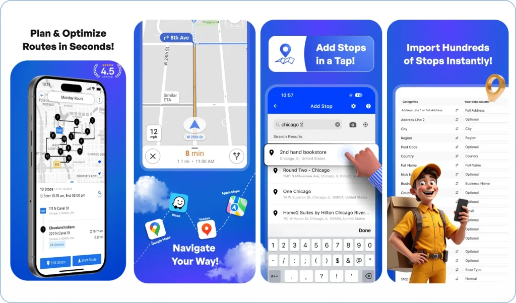
Upper is a route optimization and scheduling platform designed to help trucking operations plan faster, more efficient routes. It minimizes manual planning by generating optimized stop sequences based on distance, time windows, priorities, or delivery constraints.
Upper also provides real-time ETAs and adaptive customer notification capabilities to keep dispatchers and customers informed throughout the day.
In addition to routing, Upper supports long-term route planning through route scheduling features that allow you to create and store recurring delivery plans. Drivers can also collect digital proof of delivery, like photos, notes, and customer e-signatures, to improve accuracy and recordkeeping.
Pricing starts at $40 per user per month.
2. Waze
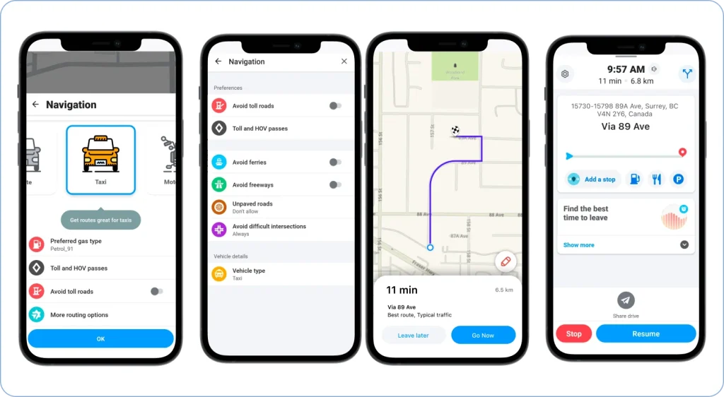
Waze is widely used by everyday drivers, but many truckers rely on it for its strong community-driven traffic insights. It provides real-time updates on congestion, road closures, weather impacts, and hazards reported by other drivers.
While Waze does not offer truck-specific routing, its live alert system helps drivers anticipate sudden road events and adjust their path digitally.
Truckers find Waze especially useful in dense urban areas where unexpected slowdowns or incidents are common. Its hands-free guidance and simple interface make it easy to use on the road.
Waze is free to use.
3. CoPilot GPS
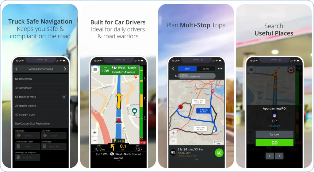
CoPilot GPS is a dedicated truck navigation solution designed specifically for commercial vehicles. It allows drivers to create custom truck profiles based on height, weight, load type, and axle restrictions to ensure routes stay compliant with road regulations.
Its built-in offline maps make it a strong choice for areas with unreliable network coverage.
The software also enables multi-stop route planning, lane guidance, and turn-by-turn instructions tailored to large trucks. CoPilot offers real-time traffic insights and rerouting options to help maintain predictable ETAs and overall schedule reliability.
Pricing starts at $8.99/month or $90.99/year for the full truck navigation plan.
4. PTV Navigator
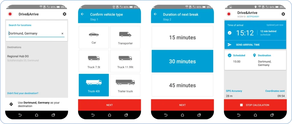
PTV Navigator is built for logistics companies seeking reliable truck-oriented navigation with accurate road data for commercial vehicles.
It creates compliant routes by accounting for vehicle dimensions, cargo type, and relevant restrictions such as low bridges or hazardous-material limitations.
The app also provides lane-level instructions, speed warnings, and updated traffic information to ensure a smooth driving experience.
PTV Navigator integrates well with dispatch systems, allowing fleets to share routes or updates directly with drivers in real time.
Pricing is custom depending on configuration and fleet requirements.
5. Trucker Path
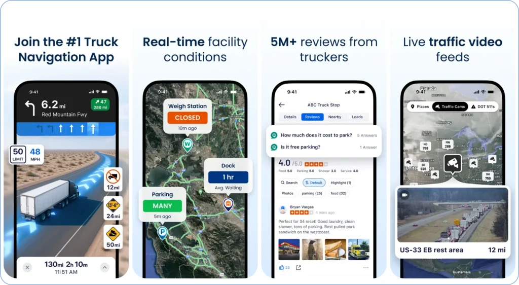
Trucker Path is a popular navigation and resource app trusted by thousands of truck drivers.
While it is not a traditional truck routing app, it provides essential trucking tools such as real-time parking availability, weigh station status, rest area information, and fuel price comparisons to support long-haul planning.
The app also offers truck-legal navigation features that help drivers avoid restricted roads and low-clearance locations.
A strong community-driven data model ensures that drivers get updated information about truck stops, amenities, and road conditions throughout their routes.
Trucker Path offers a free version for basic truck navigation and POI discovery. For advanced features, paid plans start at $9.99/month or $99.99/year for Gold, and $29.99/month for Diamond membership.
6. Sygic
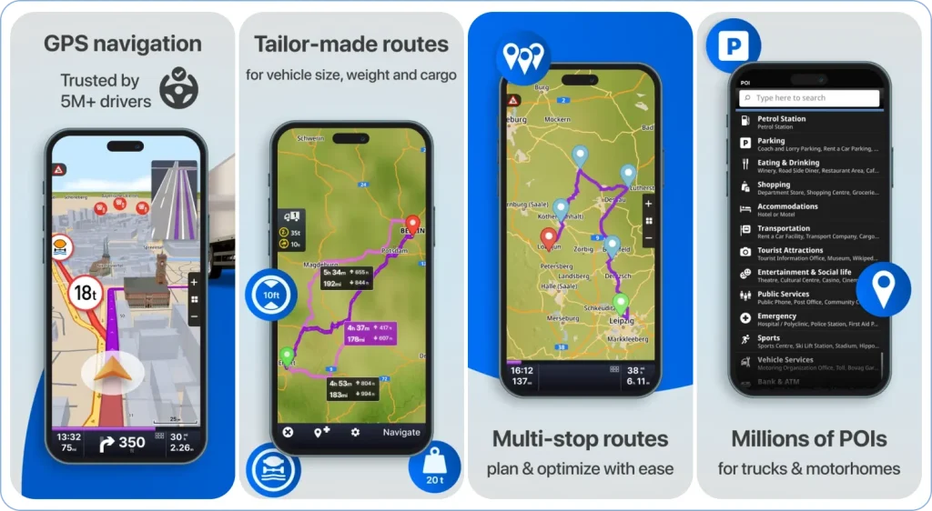
Sygic is a widely used offline GPS navigation app trusted by drivers of large vehicles.
It supports custom vehicle profiles based on truck length, height, weight, and cargo type to prevent drivers from entering restricted or unsafe routes. Sygic also helps avoid tolls, sharp turns, and U-turns by tailoring guidance specifically for trucks.
A standout feature of Sygic is its reliable offline accessibility, making it useful for remote routes with weak network coverage.
Drivers can also access information on nearby truck services, rest stops, and lounges, along with real-time alerts such as weigh station status.
Sygic GPS Truck & Caravan is free to download and includes a 7-day Premium trial. After the trial, the core truck navigation license is available as a one-time purchase, with optional add-ons for real-time traffic, speed cameras, and CarPlay support.
7. TruckMap
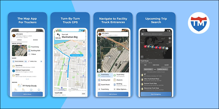
TruckMap is a free truck‑specific GPS app built for North American drivers, designed to keep trucks on legal, safe roads instead of car‑only shortcuts. It lets you set up truck profiles with height, weight, and other constraints so routes avoid low‑clearance bridges, tight streets, and restricted segments.
Beyond routing, TruckMap helps drivers find truck parking, weigh stations, truck stops, and fuel stations with real‑time information on availability and prices. This makes it especially useful for long‑haul and regional truckers who need both navigation and reliable points of interest in one app rather than juggling multiple tools.
TruckMap is free to use, which makes it appealing for owner‑operators and small fleets that want basic truck‑legal navigation and POI data without committing to a paid subscription.
Going ahead, let’s find out what you should look for while choosing your truck routing software.
How to Choose the Right Trucker Maps Software?
Choosing the right truck routing software starts with checking whether it supports truck-specific routing based on height, weight, axle count, and cargo type.
You also want real-time traffic updates, multi-stop optimization, and offline navigation for areas with poor signal.
Safety features like low-bridge alerts, hazmat routing, and lane guidance are essential, along with simple driver-friendly navigation.
Finally, consider how well the software integrates with your fleet or dispatch tools, its pricing, scalability, and the reliability of its customer support.
What are the Advantages and Disadvantages of Truck GPS Apps
Truck GPS (navigation) apps are designed to meet specific trucking needs, giving them a competitive edge over Google Maps.
The following are the benefits of deploying truck GPS apps:
1. Helps track and boost your fleet’s performance
A truck app helps analyze each route that your truck drivers traverse through reports and analytics. These reports help you know details like the total number of stops your team delivered or missed along different routes.
You can also assess an individual driver’s performance through their delivered and missed stops by day, week, or month. These insights help you find areas of improvement and take measures to improve delivery efficiency.
2. Enhances compliance with truck-specific information
A truck navigation system helps identify the routes that comply with regulations regarding height, weight, and hazardous material transportation.
Hence, it helps ensure that trucks don’t navigate weight-restricted roads or no-go zones and avoid legal implications that it could lead to.
It also establishes you as a responsible trucking company that emphasizes legal adherence, boosting your brand reputation.
3. Boosts customer satisfaction with accurate ETAs and timely deliveries
Most truck apps provide route optimization that allows you to optimize your routes based on distance, traffic, and preferred time windows. These efficient routes help your truckers achieve on-time deliveries.
Further, they enable you to track your drivers in real time and predict their estimated arrival times (ETAs) precisely. Communicating these dynamic ETAs to customers helps enhance their visibility into delivery operations, enhancing their trust and satisfaction levels.
4. Enables operational cost savings through route planning and optimization
A truck GPS app helps create optimal truck routes based on general and truck-specific constraints like height and weight. These routes help reduce the distance that your truck drivers have to cover daily to execute deliveries, lowering fuel consumption.
Moreover, minimizing distances to cover helps cut down on the wear/tear of your trucks and, hence, the need for frequent maintenance expenses. Thus, optimizing routes contributes to overall operational cost savings.
5. Facilitates convenient, driver-friendly, and safe routing
A truck navigation app is equipped with a database of crucial points of interest and truck-specific amenities, including:
- Tuck parking availability
- Rest areas
- Weigh stations
- Driver lounges
- Fuel/service stations
This information helps your truckers take appropriate breaks to refresh themselves. A rejuvenated driver is more alert and productive, preventing unsafe driving practices or delays.
When your drivers can take specified breaks, it also helps you ensure your compliance with their legal Hours of Service and avoid adherence issues.
Information on nearby service stations helps them address potential mechanical issues promptly before they hamper delivery timelines.
6. Improves fleet management through real-time visibility
A truck route app provides real-time visibility into the precise location and status of your trucks. Tracking them helps you ensure that they are following the designated path and not deviating from it.
Live tracking also lets you send your maintenance team in case your truckers face a mechanical issue or guide them to the nearest service stations, improving fleet management.
7. Allows for efficient load planning
A truck app not only helps you optimize routes but also plans your loads based on each truck’s weight and volume specifications. It lets you configure the number, permissible weight, and volume of goods for a truck.
You can then dispatch each truck on the route that has loading /unloading stops matching its load specifications. It helps optimize your trucks’ payload capacity and maximize load efficiency.
Disadvantages of truck GPS apps:
Truck GPS apps offer strong value, but they also come with certain limitations that trucking companies should be aware of before depending fully on them.
1. Higher cost compared to free navigation tools
Most truck GPS apps operate on paid subscription models. While these fees support advanced routing, compliance data, and real-time updates, they can become a noticeable expense for fleets with many drivers.
For small fleet owners or individual operators, the cost difference compared to free apps like Google Maps may feel significant.
2. Occasional inaccuracies or outdated restrictions
Even the best truck GPS systems can’t guarantee 100% map accuracy. Road closures, newly added weight restrictions, changed bridge limits, and construction updates may take time to appear in the app.
When this happens, drivers may face unexpected reroutes or delays, affecting delivery timelines.
3. Requires modern devices and stable connectivity
Truck GPS apps run heavy map data, real-time tracking, and traffic layers, which require newer smartphones or tablets for smooth performance.
Older devices may lag, crash, or heat up during long trips. Additionally, some features depend on internet connectivity, meaning drivers in remote areas might experience partial or slow navigation updates.
4. Learning curve for drivers with limited tech experience
While truck GPS apps offer powerful capabilities, they can also be complex. Features like truck profiles, axle settings, hazmat routing, and load-based restrictions need to be configured correctly to avoid unsafe routes.
Drivers who are not comfortable with technology may need training to use the app effectively.
Go Beyond Google Maps Truck Routing
Physical street maps are the talk of the past ever since online route planning has taken the trucking or virtually the entire transportation industry by storm.
While Google Maps for trucks may seem like a convenient starting point, it doesn’t fit when it comes to creating safe, compliant, and efficient commercial routes. Convenience alone isn’t enough when a wrong turn means a low-bridge fine, a missed delivery window, or a safety violation.
Google Maps might win on convenience and cost, but when it comes to trucking, it misses the mark. Without truck-specific routing or regulatory awareness, it can’t guarantee safe or efficient deliveries. If you’re considering a dedicated route planning solution, our Upper vs Google Maps comparison breaks down the key differences in routing capabilities, dispatch tools, and fleet management features.
That doesn’t mean you’re out of options; there are specialized truck GPS solutions designed to navigate the complexities of commercial trucking, from weight and height restrictions to optimized multi-stop routing. Choosing one of those can make a real difference to your operations.